Process and Context
|
collaborative public art as an engagement strategy |
|
Collaborative Public Art
Vliet Street is a major thoroughfare that connects Milwaukee to its western suburbs. During interviews and workshops with local residents we found that the speed at which people moved through this street was seen as a problem. The issue was not how much traffic moved through the site, but rather the speed at which cars and buses ferried across this road. Vliet Street was not a destination or a neighborhood street with a vibrant public life—automobile drivers had nothing that would cause them to slow down. Our research also demonstrated that movement along Vliet St. happened at different speeds—pedestrians walking at a determined pace along the sidewalks, buses and cars zipping by and slower bicyclists sharing the road. As a result, pedestrians, bus commuters, residents, and drivers experienced the street differently and at different scales. A driver for instance saw the street as fleeting space, the major signs and buildings appearing as icons. Pedestrians, in contrast, had a closer look at storefronts and sidewalks. Those waiting at the bus stop saw the building and sidewalks around them, in detail, over a longer period of time. We looked for input from the community by asking the question ‘What makes you slow down?” We went to the Washington Park Library and put a cardboard sign asking that question. Visitors to the library such as local young adults, wrote their responses on the board. Next, we made a cardboard cutout, shaped like the human figure in a pedestrian crossing sign, alluding to the pedestrian presence on the street. The cardboard cut-out asked the same question. We took the cutout to the popular Lisbon Avenue Arts Fair and fair visitors wrote their responses directly on the cutout. The responses from the community inspired us to create an installation meant to raise awareness of pedestrian and neighborhood residents' life on the street. Collecting our past experiences, we crafted a larger-than-lifesize sign and hung the sign from an abandoned custard stand pylon. The installation sign was placed near a pedestrian crossing and next to a bus stop. The artwork therefore performed a functional use as well as an aesthetic one. Life-size pedestrian cutouts were also placed throughout the neighborhood. The objective of this installation was to brand Vliet Street by utilizing a color palette taken from existing signs and spaces on the street. During the construction process we met many local residents commuting on Vliet Street. Many stopped and helped us paint and erect this sign. Local children, on their way back from school, got down from the bus and joined us in painting the sign. This sign raised awareness of residents living in the area. This installation was a starting point to explore a vision for a revitalized Vliet St. Our design projects reflect lessons learnt during this collaborative art installation. Our project reflects the DIY hands-on methods suggested by designers engaged in tactical urbanism, a collaborative engaged process for community engagement and urban design. |
Primary engagement strategy
Interactive art installations were our primary strategy of engagement. Here you see images of students erecting a large sign on Vliet Street in order to draw in local residents and children. The making of this installation became a community event with local residents and children pitching in to help. Other events such as the sign installation at the Lisbon Avenue Arts Fair and the Washington Park Library invited residents and users to jot down their ideas and thoughts on street intersections. All these events inspired and generated subsequent design projects. Facade redesign for local businesses
Students worked with local business owners in order to propose facade redesigns that would be sensitive to the needs of the retailers and appropriate for the streetscape. 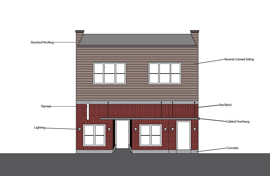

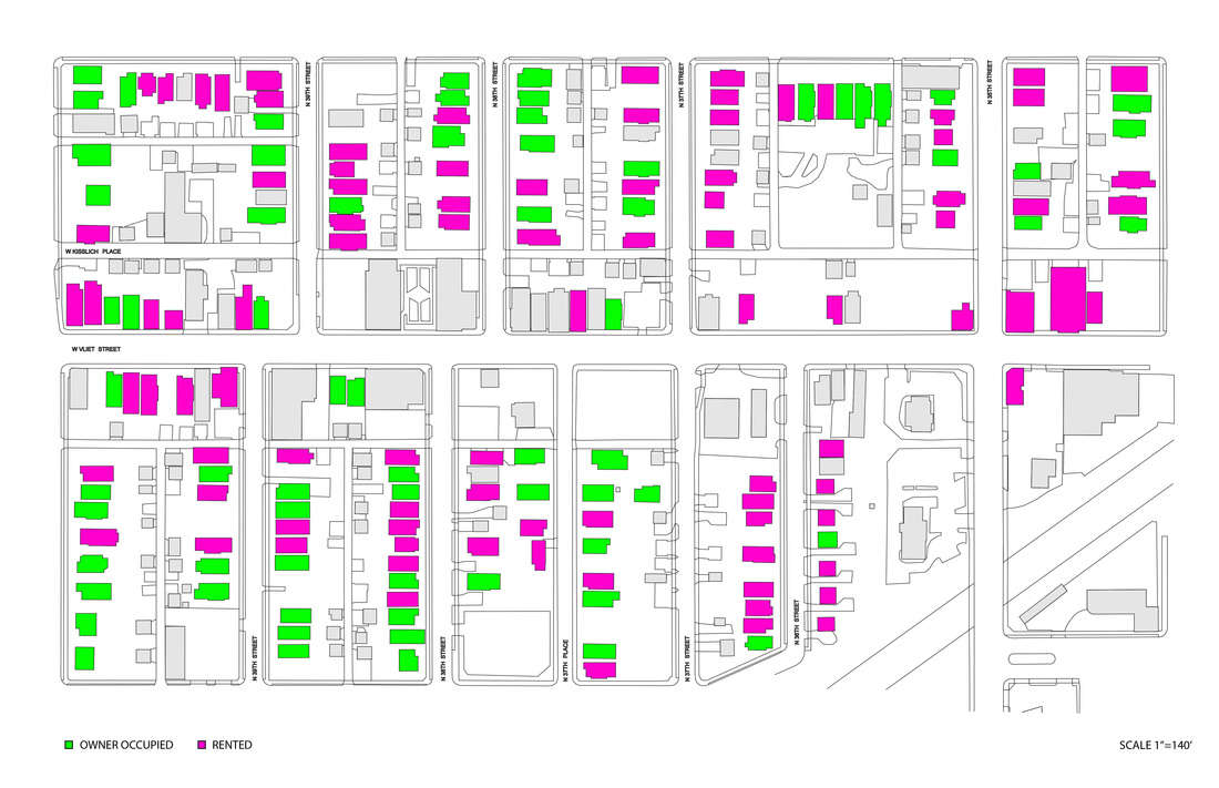
In order to understand and document Vliet Street we mapped the street in multiple ways. Mapping allows us to systematically render certain aspects of the built environment as a way to visualize the street.
|